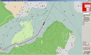
SeaClear is an OpenSource navigation programme.
Download
for Windows
Data Formats for Charts
For OpenSeaMap: KAP and WCI
Other: BSB
Install Charts
- Save charts locally in folders
sub-folders are possible - run MapCal.exe
- Click on the "Tool" tab
- choose your folder with the charts in "Set Directories"
- execute the Autoload Lista (all 3 )
- close Mapcal
- launch SeaClear and start working
Features
Displays the ships position on the chart (with the GPS signal)
Displays position, speed and course
Log, Triplog, running hours
depths, wind direction and force
sets waypoints
edist routes
inversion of routes
activates/de-activates routes
Shows start, finish and distance
import/export of routes and waypoints
Autopilot operation (with NMEA)
track-recording
import/export of tracks
displays AIS signals
night-colors (4 levels)
